Interpretive signage and/or lesson plans have been developed for Glen Cove Mixed-Use Waterfront Redevelopment (Glen Cove, NY), Hubbard County Park (Flanders, NY), Long Island Aquarium & Exhibition Center (Atlantis Marine World, Riverhead, NY), Mud Creek County Park (East Patchogue, NY), and Paumanok Preserve (Huntington, NY).
Archives: Slides
ENVIRONMENTAL EDUCATION AND INTERPRETIVE SIGNS
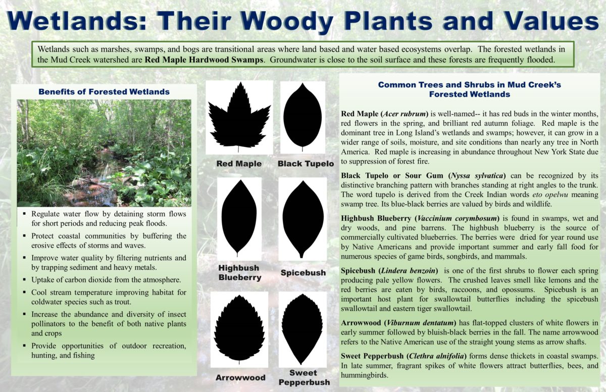
Land Use ecologists are also experienced educators specializing in the development of interpretive signage and lesson plans on a variety of biological and ecological topics. Restoration of native wetland and upland habitats and associated public amenities creates educational opportunities for students and the public about Long Island’s natural resources and their history.
Regulatory Compliance
Land Use represents property owners and contractors that have been issued violations from governmental agencies for non-compliance with environmental laws and regulations. Violations are usually settled by fine and/or restoration of natural habitat. Land Use negotiates applicable fines with government agencies and develops restoration plans to bring a site in to compliance with regulations.
Wetland Delineations, Natural Resource Inventories, and Ecological Studies
Land Use biologists and ecologists are experienced in the delineation of freshwater and tidal wetlands according to federal (Section 404) and state (Articles 24 and 25) regulations. Our staff has delineated over 2,000 wetlands throughout Long Island, New York City, New Jersey, and the Hudson Valley.
Our staff are experts in the identification of Long Island’s native wildlife, vegetation, and ecological communities. Our staff analyzes the impacts of a project on a site’s natural resources and makes recommendations for the preservation and protection of valuable habitats including freshwater wetlands, tidal wetlands, and significant upland habitats. Land Use scientists have excellent writing and communication skills and are adept at translating the findings of field studies into well-prepared and organized reports including Environmental Impact Statements, Environmental Assessments, Natural Resource Inventories, and Essential Fish Habitat Assessments.
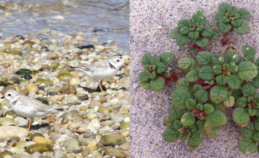
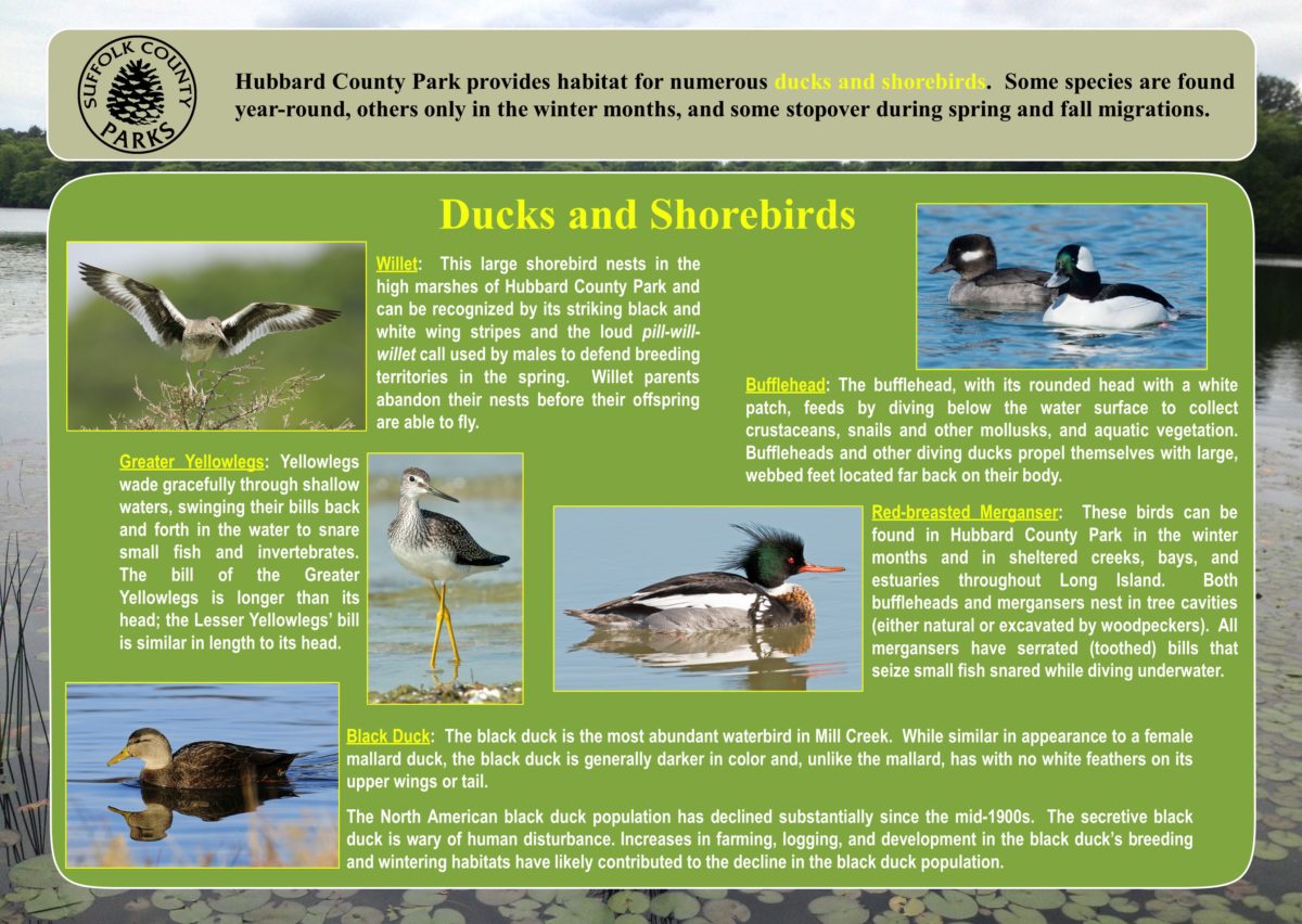
Land Use is one of the few firms certified by NYSDEC and the USFWS for endangered species monitoring in environmentally sensitive areas. Our biologists and ecologists are trained in identification of endangered species such as piping plover (Charadrius melodus) and seabeach amaranth (Amaranthus pumilus), among many others.
Once Land Use scientists have identified an endangered species, we make recommendations for the preservation and protection of its valuable habitat.
ENVIRONMENTAL IMPACT ANALYSIS
Projects
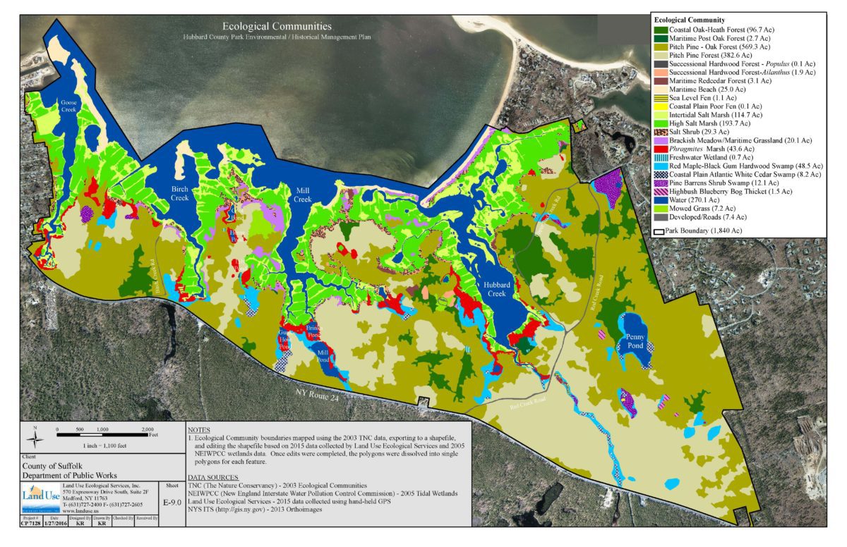
Natural Resource Inventories and Ecological Communities Maps:
• Eastport Conservation Area and Pine Meadows County Park (Eastport, NY), Glen Cove Mixed-Use Waterfront Redevelopment (Glen Cove, NY), Hubbard County Park (Flanders, NY), Mud Creek County Park (East Patchogue, NY), Nissequogue River – Northeast Branch Restoration (Smithtown, NY), Rocky Point Natural Resources Management Area (Ridge, NY), Sarnoff State Pine Barrens Preserve (Flanders, NY)
Essential Fish Habitat Assessments:
• Fire Island Community Short-Term Storm Protection Projects (Fire Island, NY), Glen Cove Mixed-Use Waterfront Redevelopment (Glen Cove, NY), Seawanahaka Corinthian Yacht Club (Centre Island, NY), Village of Ocean Beach Marina (Ocean Beach, NY)
Biological Assessments:
• Fire Island Community Short-Term Storm Protection Projects (Fire Island, NY), New Bedford Marine Commerce Terminal (New Bedford, MA)
Land Use prepares Environmental Impact Statements and Environmental Assessments, inclusive of required ecological studies), according to the State Environmental Quality Review (SEQR) Act and National Environmental Policy Act (NEPA). Land Use has prepared impact statements for a variety of projects, such as the following:
• Fire Island Short-term Storm Protection Projects, Suffolk County, NY (2008)
• Harbor View Estates, Copiague, Suffolk County, NY (2007).
• Manhasset Glen II Subdivision, Plandome and Plandome Manor, Nassau County, NY (2004).
• Western Fire Island and Fire Island Pines Beach Nourishment Project, Suffolk County, NY (2003).
In addition, Land Use has prepared numerous Natural Resource Inventories, Ecological Communities Maps, Essential Fish Habitat Assessments, and Biological Assessments. Our staff are experts in identification of vegetation, birds, mammals, herpetiles (reptiles & amphibians), and finfish. Staff will inventory species and habitat types observed and/or expected in an area, and analyze potential impacts of a proposed project on that ecosystem.
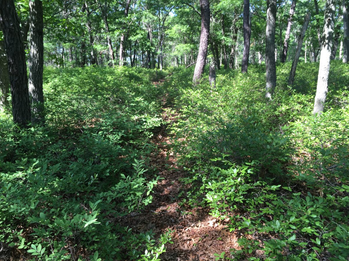
Inland Habitat Management and Restoration
The successful management and restoration of any ecosystem requires
sufficient inventory data on existing ecological conditions
understanding of the ecosystem’s fundamental ecological and physical characteristics, and knowledge of the life history and habitat requirements of target species,
clear and measurable management objectives to guide the implementation restoration projects,
proper experience and training with implementation of restoration strategies (particularly with prescribed fire as a restoration strategy) and
careful design and implementation of pre- and post-project monitoring protocols to verify the achievement of management restoration goals. While habitat restorations must be guided by ecological parameters, project success is equally dependent on the support of project partners and municipalities. Land Use’s ecologists possess an in-depth understanding of the social climate of Long Island and the ability to work with State, County, and local governments and other stakeholders to anticipate and solve challenges that arise.
Projects:
- Hubbard County Park Environmental and Historical Management Plan (Flanders, NY)
- Sarnoff Preserve Forest Restoration and Fuel Management (Flanders, NY)
- Rocky Point Natural Resources Management Area Barrens Restoration and Fuel Management (Rocky Point, NY)
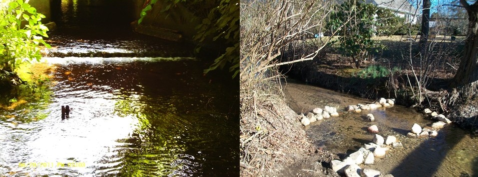
Fish Passage Restoration
Fish passage and habitat restorations require a thorough understanding of the physical environment characteristics required by the target species and their interactions with other species. Land Use partners with scientists and engineers that are highly experienced in fish passage and restoration of riparian and upland habitats. Fish passage restoration projects that Land Use is involved with include:
Peconic Estuary Conceptual Habitat Restoration Project, Suffolk County, NY.
Alewife Brook Fish Passage Restoration, Southampton, Suffolk County, NY.
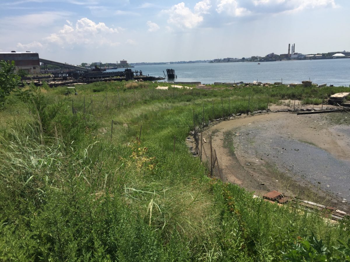
Shoreline Restoration
Land Use also prepares plans to restore shorelines to natural conditions, develops specifications for plans to restore degraded bluffs, and manages dune restoration projects along Long Island’s oceanfront.
Natural methods of shoreline protection and erosion control are favored by the NYSDEC, Fire Island National Seashore, and local regulatory agencies. Land Use prepares site plans that utilize native beach and wetland vegetation to stabilize shorelines. Stones or boulders are installed only in erosion-prone areas or to stabilize banks, bluffs, or slopes. Land Use prepares site plans that utilize the best methods to protect upland areas, maintain natural shorelines as valuable habitat, and maximize the likelihood for approval by regulatory agencies.
Restoration of bluffs usually involves development of a grading plan to obtain a stable slope and a revegetation plan to hold the slope in place. In cases where hard structures such as retaining walls or gabion walls are required for bluff stabilization, Land Use works with an engineer to develop a sound bluff stabilization structure. Land Use prepares plans based on specific project needs and obtains approvals from regulatory agencies.
Dune Restoration is often required in oceanfront communities to protect residences and property from coastal storms. Land Use provides necessary planning services for dune restoration projects. Land Use conducts profile surveys of elevation(s) of eroded beach and dune areas. Profiles are necessary to document existing conditions for regulatory agencies and to determine the volume of sand required for restoration. Land Use then prepares plans and project specifications for submission to regulatory agencies.